Joanna Hills Estates, Avon, MA
Joanna Hills Estates, Avon, MA
EXISTING CONDITIONS (SITE DESCRIPTION)
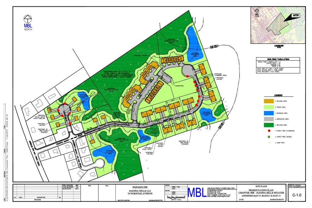
The project is located at the end of Joanna Road in Avon, Massachusetts. The site is referenced as Lot 15 on Assessors Map C-7 Block 3 containing a total of 29.37 acres. The existing site consists of a vacant wooded lot consisting of a total upland area of 19.86 acres with 9.51 acres of wetlands.
A portion of the northernmost part of the site lies within a FEMA Flood Zone A, areas of 1% chance flooding with Base Flood Elevations not determined as shown on FIRM Map No. 25021C0218E, having an effective date of July 17, 2012. This portion of the site was removed from the Flood Zone after filing for a Letter of Map Amendment Determination with FEMA. The 1% annual chance flood elevation was determined by FEMA to be elevation 213.0 NAVD 88.
The site is not located within an Estimated Habitat of Rare Wildlife or Priority Habitat of Rare Species or near a Certified Vernal Pool according to the Massachusetts Natural Heritage Atlas, 14th Edition effective August 2017. The site is also not located within an ACEC, Outstanding Resource Water or any other Critical Area.
BORDERING VEGETATED WETLANDS
The boundary of the Bordering Vegetated Wetlands (BVW), Isolated Vegetated Wetland (IVW) and Isolated Land Subject to Flooding (ILSF) located on-site was delineated by MBL Land Development & Permitting, Corp. An Abbreviated Notice of Resource Area Delineation showing the resource areas was submitted to the Avon Conservation Commission and approved through an Order of Resource Area Delineation (ORAD) issued by the Commission on June 8, 2017. The ORAD was extended on April 1, 2020. A copy of the ORAD and approved ANRAD plan can be found in Appendix A of this report.
PROPOSED CONDITIONS
The proposed project is a Chapter 40B development containing a total of 76 proposed units with associated site access, parking, grading, drainage and utilities including on-site subsurface disposal systems. These units are comprised of 9 single family dwellings, 11 duplexes, one 7-unit condominium building, one 10-unit condominium building and two 14-unit condominium buildings. To mitigate the quantity and quality of stormwater runoff discharging from the site, a stormwater management system has been designed to collect, treat and control flows leaving the site. The proposed stormwater management system consists of a series of deep sump hooded catch basins, pipes and manholes, which will collect and convey stormwater runoff to proposed water quality units and vegetated infiltration basins. The proposed infiltration basins have been designed to store the required recharge volume and have riprap overflow spillways with one foot of freeboard. Also, where feasible, roof recharge systems were added to recharge roof runoff on-site. These systems consist of Cultec 330XLHD chambers designed to recharge the entire 100-year storm. The stormwater management system has been designed to reduce peak flow rates from the existing to proposed conditions for all storm events. From an environmentally sensitive perspective, the aforementioned measures result in a design that promotes on-site groundwater recharge while preserving the natural hydrologic conditions.
PROJECT IMPACTS
Portions of the proposed project are located within the 100-foot wetland buffer zone, including 6 single-family houses, 5 buildings, 5 drainage basins, and roadway construction. All septic systems are located at least 50-feet from the edge of BVW and all buildings are located at least 25-feet from the edge of BVW. No work is proposed within the BVW or ILSF, and therefore no replication is proposed for the project. The 1,411 S.F. Isolated Vegetated Wetland (IVW) will be completely filled, but since IVW is not subject to the State Wetlands Protection Act no replication for this filling is required.
Joanna Hills Estates, currently a wooded site consisting of 29.37 acres, is located east of Page Street and at the end of Joanna Road in Avon, MA. The property is situated in a residential area and abutting properties to the east are owned by the Town of Avon. The wetland resource areas as delineated was approved by Avon Conservation Commission.
The development has a total of 76 single family and multi-family homes (Fee Simple) of which 19 homes/units (25%) will be sold to affordable buyers with a median income of 80%. The site design features sustainable development technologies to minimize the impact on the environment site design, stormwater management and waste water infiltration.
PERMITTING REQUIREMENTS
1)Conservation Commission Approval in Avon, MA
2)Zoning Board Approval (40b Application and Plans) Avon, MA
3)Wetland Delineation and Approval, Avon, MA
4)ALTA/NSPS survey is an in-depth land map that details a property’s permanent improvements, utilities, and observable features, all of which are necessary requirements requested by lenders, title agents, buyers, and sellers during real estate due diligence to determine any potential risks and/or benefits.
5) Multiple Septic System Designs and Board of Health Approval in Avon, MA
6) FEMA Letter of Map Amendment and Revision.
MBL continues to provide Construction Phase Services as well as Construction Survey Stakeout for the development of these Four sites.